
Critical Resources Ltd (ASX:CRR, FRA:9S70) has completed a detailed desktop study at its Lammerlaw Gold Project in New Zealand's Central Otago Goldfields, identifying three high-priority exploration targets across the 410 km² permit area — and setting the stage for ground-level work once regulatory approvals come through.
Lammerlaw sits on the southwestern flank of the Central Otago Antiform, the same regional structure that hosts OceanaGold's multi-million-ounce Macraes operation on its northeastern margin. Despite the region's strong gold pedigree, which also includes Santana Minerals' emerging Bendigo-Ophir discovery, Lammerlaw has seen only scattered, reconnaissance-level exploration in modern times.
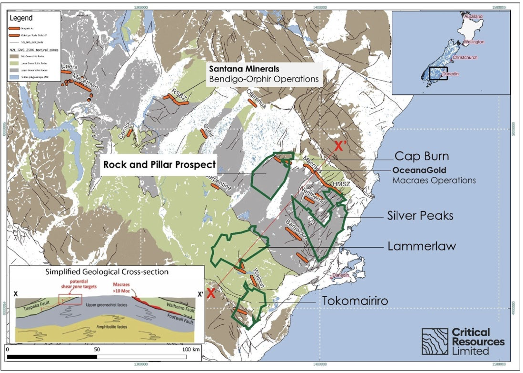
Location of the Lammerlaw permit showing blocks of different metamorphic facies and the main historic orogenic gold deposits, including the currently active Macraes mine on the northeastern margin. The simplified schematic cross section (modified from Mackenzie et al., 2017) illustrates the structural symmetry of the Otago Schist Belt and the interpreted position of lower greenschist facies schists prospective for shear hosted orogenic gold mineralisation.
For CRR, the project adds a second exploration front to its gold portfolio, sitting roughly 50 kilometres south-southwest of the company's flagship Cap Burn Gold Project. Assay results from a recently completed RC drilling program at Cap Burn are expected in early March, subject to laboratory turnaround times in New Zealand.
Managing director Tim Wither said the desktop study had validated the geological rationale for acquiring Lammerlaw, pointing to well-defined shear corridors and multiple structurally coherent target areas consistent with orogenic gold systems across the Otago Schist Belt.
"Lammerlaw was secured on the strength of its geological prospectivity, and the detailed desktop study has now validated that decision. The work confirms well-defined shear corridors and, importantly, multiple structurally coherent target areas consistent with orogenic gold systems in the Otago Schist Belt. These refined targets provide a clear foundation for systematic, low-cost field programs designed to test the structural interpretations and advance our understanding of the permit area. Lammerlaw complements Cap Burn and supports our strategy of building opportunities across a proven and highly prospective gold province in New Zealand."
Three targets locked in
The desktop study, completed ahead of anticipated permit transfer approval from New Zealand Petroleum and Minerals (NZP&M), drew on historical mining records, high-resolution aerial imagery, LiDAR terrain data, legacy geochemistry, and regional airborne geophysics to build a coherent geological picture of the permit.
The host rocks — Textural Zone 3 and 4 schists (TZ3, TZ4) — are the same rock types that host low-angle, shear-controlled deposits at Macraes and Bendigo-Ophir. Structural analysis also points to a potential mirror image of the Hyde-Macraes Shear Zone sitting beneath the Lammerlaw permit, though the company notes this interpretation remains conceptual until confirmed in the field.
The study has produced three clearly defined priority targets, each supported by a different combination of historical evidence and modern data.
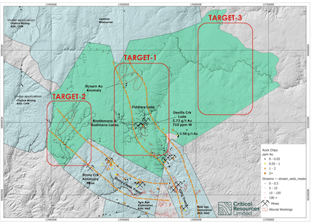
Lammerlaw permit showing locations of prospect targets and historic mine workings.
Target 1 — Devils Creek: The historic hard rock prospect
Devils Creek is the most historically developed hard rock gold site within the permit, featuring two small adits, numerous pits, and prospect trenches that have been confirmed and mapped through aerial imagery and LiDAR. Historical rock chip samples from the area returned grades of 2.72 grams per tonne (g/t) and 2.58 g/t gold, with tungsten values reaching 710 ppm — a pathfinder element commonly associated with orogenic gold systems.
The alignment of underground workings and surface excavations points to mineralisation along a coherent lode or shear structure rather than isolated veins, which is consistent with the style of gold deposits found elsewhere in the Otago Schist Belt. The inferred strike of the lode has now been mapped with greater confidence, providing a clear framework for follow-up surface sampling along strike and beyond the historically worked zones.
Target 2 — Stony Creek: A geophysics-supported multi-commodity system
The Stony Creek Trend stands out for the coincidence of historic antimony workings — including reported test shipments grading 47% antimony — with a distinct electromagnetic anomaly visible in regional airborne geophysical data. Stream sediment sampling across the broader catchment has returned tungsten values up to 340 ppm, further supporting the presence of a structurally focused mineralising system at depth.
Both antimony and tungsten are well-established pathfinder elements for orogenic gold, and the Stony Creek corridor has not been tested with modern exploration techniques — meaning genuine discovery potential remains. The electromagnetic feature provides a mappable geophysical framework to guide that work.
Target 3 — TZ3–TZ4 structural boundary: The Regional-Scale Opportunity
The interpreted boundary between Textural Zone 3 and Zone 4 schists crosses the permit area and represents a regionally significant rheological contrast. In the Otago Schist Belt, such contacts are known to localise strain and focus fluid flow — the key ingredients for orogenic gold mineralisation. This boundary is conceptually analogous to the structural setting at Macraes and provides the broadest, most regional scale of the three targets.
What the historical record shows
Beyond the three defined targets, the broader permit area has yielded a string of encouraging signals from past exploration. Extensive alluvial gold workings — identified through aerial imagery and LiDAR — are spread across multiple drainage systems, interpreted as evidence of proximal bedrock gold sources within surrounding structural corridors.
Just outside the permit boundary, the Otago Pioneer Quartz Mine — one of the earliest hard rock gold operations in the region, discovered in the 1860s — was reportedly mined over more than 1,200 metres of strike at historical average grades of around 13-15 g/t gold. The structural trend hosting that deposit extends toward the Lammerlaw permit area.
Previous operators including BHP, Welcome Gold Mines, Glass Earth Gold, and Lammer Resources all identified localised gold and pathfinder anomalies within or adjacent to the permit, but none conducted systematic soil geochemistry, structural mapping, or drill testing within the core structural corridors — leaving the ground largely uncontested by modern methods.
Next Steps: Low-cost, staged field programs
Near-term work will focus on Devils Creek and Stony Creek, with an emphasis on cost-effective, high-information activities designed to validate the desktop interpretations before any more capital-intensive work is committed.
Planned activities include ground reconnaissance and structural mapping, targeted rock chip and soil sampling along the inferred Devils Creek lode strike and Stony Creek corridor, ground-truthing of the Stony Creek electromagnetic anomaly, and progressive refinement of the geological model as field data comes in.
All of this is contingent on NZP&M approving the transfer of the Lammerlaw permit to Critical Resources' subsidiary Goldfire Resources, which has entered a binding agreement to acquire a 90% interest in permit PP61276.