
Miramar Resources Ltd (ASX:M2R) has an airborne electromagnetic (EM) survey underway over its 100%-owned Mt Vernon nickel-copper-PGE target in the Gascoyne region of Western Australia.
The new Versatile Time Domain Electromagnetic (VTEM) survey is being flown by UTS Geophysics and will cover the entire tenement with N-S lines spaced 400 metres apart.
This new, more detailed EM survey will provide the company with a project-scale dataset to work with for the first time. It will help M2R focus on the most prospective parts of the project for further work.
The Mt Vernon target is one of several pending or granted exploration licences, which make up the company’s Bangemall Project, covering a total of 1,750 square kilometres, which Miramar believes is prospective for Proterozoic craton margin-related nickel-copper-PGE mineralisation and/or rare earth elements (REE) mineralisation.
Great project-scale dataset
Miramar executive chairman Allan Kelly said the company was excited to see what the more detailed EM survey data might reveal about the project.
“The Mt Vernon target is a very large land position with some exciting regional-scale indications of potential njickel-copper-PGE mineralisation.
“The major crustal-scale structures indicate a potential plumbing system whilst the regional-scale geochemical and geophysical surveys highlight potential evidence for sulphide deposition.
“This new, more detailed EM survey will give us a great project-scale dataset to work with for the first time, which will help us focus in on the most prospective parts of the project for further work.”
Mt Vernon target
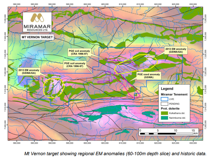
The 437 square kilometres Mt Vernon target (E52/3893) is characterised by historical PGE stream sediment and soil anomalies associated with Proterozoic dolerite sills adjacent to major crustal-scale structures.
The largest of the historic soil anomalies at Mt Vernon stretches for almost 10 kilometres on the margin of a dolerite sill, with palladium values up to 25ppb.
The 'Capricorn AEM TEMPEST Survey', completed by GSWA and Geoscience Australia in 2013, previously highlighted two large EM anomalies at Mt Vernon with 5 kilometres spaced N-S lines.
Minimal drilling
There is minimal historical drilling in the area and none completed as part of any previous nickel-copper-PGE exploration.
Previous reverse circulation (RC) drilling in 1996-97 was focused on testing for copper-lead-zinc mineralisation.