
PolarX Ltd (ASX:PXX) has expanded its Nevada landholding with a further 15 claims on the Black Canyon lode within the Humboldt Range Gold-Silver Project after confirming the presence of several large gold anomalies.
PXX is an advanced mineral explorer and developer with rapidly growing high-grade copper, gold and silver projects in the USA.
Field studies of soil and rock-chip sampling have identified two areas of particular interest amongst the prospective anomalies which the company believes warrant further infill sampling to define precise drilling targets.
The two anomalous areas have been identified as high-priority targets hosting soil and chip results of:
- 793 ppb gold in the soils, 43.8 g/t gold and 86.1 g/t silver in rock-chip sampling in the east and;
- 245.9 ppb gold in the soils with rock chip samples assayed over 100 g/t gold and peak values of 512.7 g/t gold in the west.
Infill drilling to develop precise drill targets is slated to begin this month.
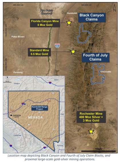
The claims sit at the northern end of the Humbolt Range, already hosting the Florida Canyon mine and further to the south the Rochester mine, holding a combined mineral resource of 8 million ounces of gold and 400 million ounces of silver across both operating mines.
Highly prospective target areas
Soil sampling was completed by PolarX on an east-west 200-metre by 50-metre grid. Initial geological mapping and rock chip sampling of quartz veins were also undertaken.
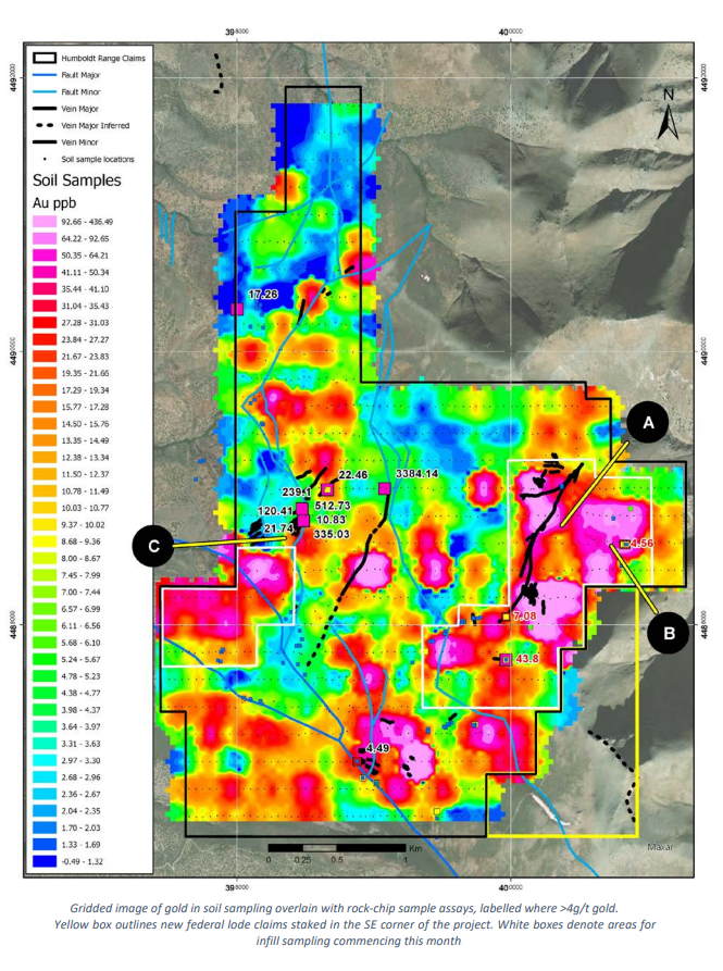
Soil sampling identified several prominent gold-in-soil anomalies with gold values exceeding 50ppb in thin residual soils. See the map below for a gridded image of soil and rock-chip sampling overlay:
Eastern anomalies
The eastern gold anomaly (designated A on the map above) covers a strike length of 2.3 kilometres with 800 metres of width at the head of Star Canyon. Soil sampling returned values of up to 793 ppb gold, while rock-chips returned up to 43.8 g/t gold and 86.1 g/t silver from quartz veins within the soil anomaly.
A second anomaly to the immediate east (designated B) is at the break in a slope with extensive outcropping ridges of intensely silicified and oxidised volcanic rocks hosting multiple quartz vein arrays and old gold-silver workings.
This second eastern anomaly extends more than 400 metres of strike with up to 200 metres of width before being concealed beneath thin soils to the north and south.
According to PolarX, “this area now represents the best-known target in the entire project for large tonnage, low-moderate grade mineralisation.”
Western Anomalous area
The second anomalous area of note occurs in the western part of the claim block (designated C) to the immediate south of the Lois Veins and Midas workings. Several rock chip samples assayed over 100 g/t with a peak value of 512.7 g/t gold.
Cliff formations in the target area host numerous sub-vertical quartz veins ranging from 5-40 centimetres in thickness, associated with silica flooding of the surrounding rocks. Further to the south is a prominent gold in soil anomaly which will require infill mapping and sampling.
Additional claims and next steps
PXX staked 15 additional federal lode claims to the south of the large, extended eastern gold anomaly. This new tenure covers potential extensions of identified gold and silver mineralisation.
Permitting for drilling will begin immediately following the completion of infill programs, with initial soil sampling and geological mapping to be undertaken over the 15 new claims.
A program of detailed infill will commence later this month in the two areas selected as a high priority for drilling. This program will include:
- Infill soil sampling to a 100-metre x 25-metre grid;
- Detailed geological and alteration mapping;
- Structural mapping of quartz veins arrays, and
- Channel sampling across the strike of vein arrays/alteration zones.