
Charger Metals NL (ASX:CHR) is planning to undertake a SkyTEM aerial electromagnetic survey next month on its Coates nickel-copper-cobalt-platinum group elements (PGE) project near Perth in Western Australia.
The Coates Project is 70% owned by Charger, while the remaining 30% is held by Lithium Australia NL (ASX:LIT).
The SkyTEM survey will test the Coates mafic intrusion and surrounding ground for conductors, including previously defined nickel-copper and PGE geochemical targets.
The helicopter-borne geophysical system, SkyTEM, is used to detect conductive rocks that may include sulphide minerals containing nickel, copper, cobalt and PGEs.
Work program to cover three projects
Charger managing director David Crook said: “With Charger Metals completing its listing on July 9 this year, we are moving to implement the work programs on our three projects, as set out in the company’s prospectus.
“We are pleased to have locked in the timing of the SkyTEM program over the Coates nickel-copper-cobalt-PGE project and keenly await the results.”
Aerial EM surveys
Aerial electromagnetic (EM) surveying is an exploration technique used to target large areas that are considered prospective for nickel sulphides in an effective and time-efficient manner. Promisingly, this method has been used successfully by many of Charger’s neighbours in the Julimar district.
The SkyTEM system is well-suited to areas of thick bush and variable topography, which can reduce the efficiency of ground-based EM systems.
The Coates Project
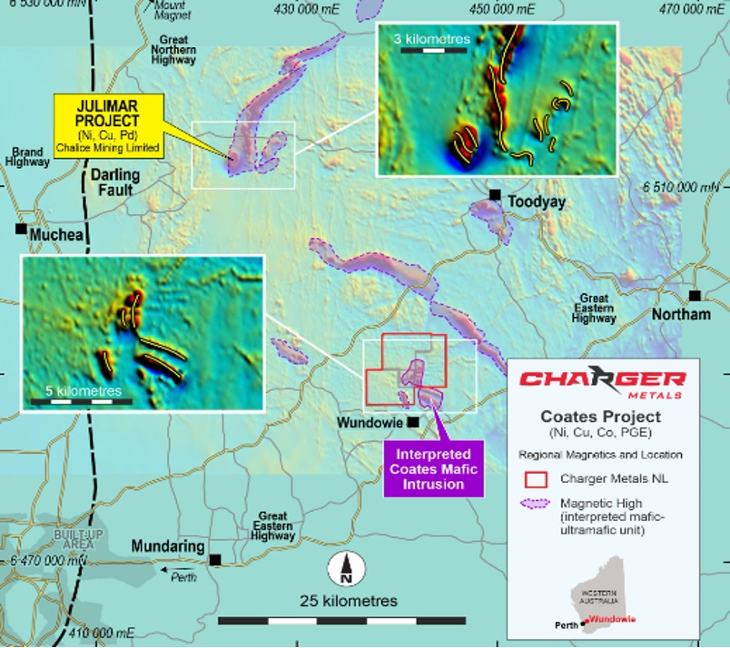
Map of Charger's Coates Project.
The Coates Project is located around 60 kilometres east of Perth at Wundowie in WA. A vanadium-titanium magnetite deposit, hosted in a mafic intrusive suite of rocks, was briefly mined near the Coates Project before closing in 1982.
The project’s regional geology is largely interpreted from geophysical data due to the poor outcrop. It includes highly deformed Archean gneisses and mafic/ultramafic rocks intruded by mafic and granitoid bodies.
The SkyTEM geophysical system
Charger’s proposed survey will utilise the helicopter-borne SkyTEM312 time-domain electromagnetic system.
Essentially, this technology is a high resolution, surface-to-depth exploration tool that provides mineral exploration data for use across a project’s lifespan.
High-resolution, near-surface data can facilitate groundwater modelling, overburden thickness calculations for seismic and mine planning, and before-and-after studies for mine rehabilitation.
Simultaneously, conventional, deeper-looking EM work may detect units down to 300 metres to 400 metres deep.
The raw SkyTEM data will be available within days of the survey’s completion, after which it will be processed and analysed by the company’s geophysics consultant before it is released to the market.