
Critical Resources Ltd (ASX:CRR, FRA:9S70) has defined three priority gold-antimony exploration targets at its Silver Peaks Project in Otago, New Zealand, after a review of more than 1,250 historical soil and stream-sediment records narrowed a large permit area into focused zones for field testing.
The targets — Lamb Hill–Three O’Clock, Stone Burn South and the Northern Soil Anomaly — lie within the 497.69-square-kilometre Silver Peaks Prospecting Permit, in which Critical Resources holds a 90% interest through wholly owned subsidiary Goldfire Resources Ltd.
Silver Peaks sits immediately south of the Hyde–Macraes Shear Zone, with Stone Burn South and the Northern Soil Anomaly positioned south of OceanaGold’s Macraes gold camp, New Zealand’s largest active gold operation.
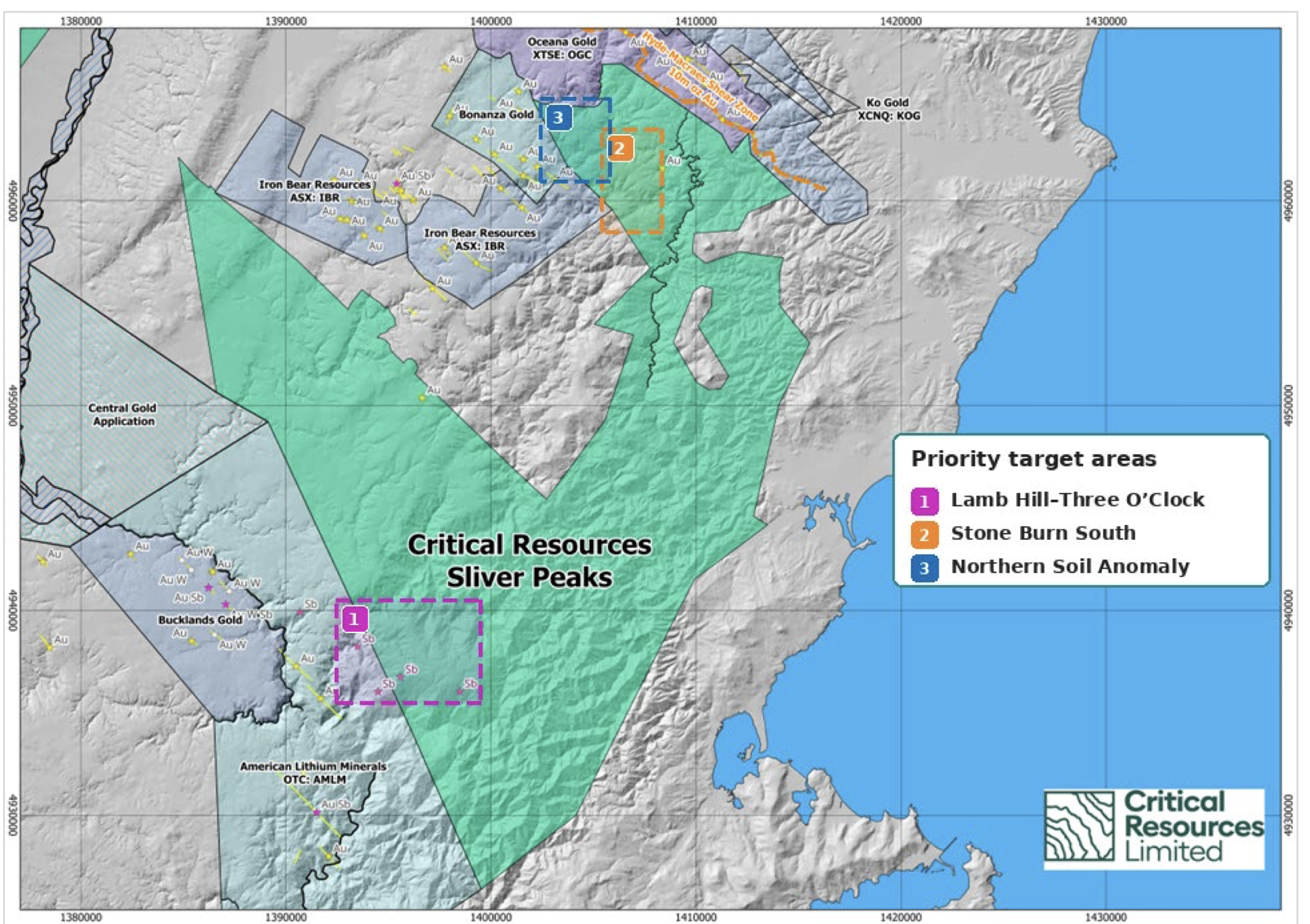
Silver Peaks PP 61275 showing the interpreted regional structural corridor and the three target areas.
Three targets emerge from historical data
Lamb Hill–Three O’Clock has been ranked as the highest-priority target. Six historical stream-sediment samples returned between 7.5 and 13.0 parts per billion (ppb) gold alongside arsenic values of up to 34 parts per million (ppm). The area also contains two historical antimony lode occurrences about 3 kilometres apart within an interpreted northwest-trending mineralised corridor.
At Stone Burn South, historical sampling returned stream-sediment results of 45.2 and 39.3 ppb gold, supported by later soil results of up to 68 ppm arsenic and 17 ppm antimony. The combined gold, arsenic and antimony signature provides a target for early-stage field investigation.
The Northern Soil Anomaly contains several historical gold-arsenic results, including 16.0 ppb gold with 34 ppm arsenic, 10.0 ppb gold with 42 ppm arsenic and 10.5 ppb gold with 24 ppm arsenic. A separate historical soil location returned 57.5 and 58.5 ppb gold from two different size fractions.
Critical Resources cautioned that the historical results are exploration vectors rather than bedrock grades and have not yet been verified through modern sampling. No drilling was identified at the three target areas in the material reviewed.
Company sees clear focus for fieldwork
Critical Resources managing director Tim Wither said the historical work had transformed a large dataset into areas that could now be assessed systematically.
“The historical review has resolved a large permit-scale dataset into three clear areas that can now be tested efficiently in the field,” Wither said.
“At the Northern Soil Anomaly, gold and arsenic occur together across several composite samples, while Stone Burn South combines earlier gold-in-stream results with later arsenic and antimony pathfinder geochemistry.
“At Lamb Hill–Three O’Clock, the historical geochemistry and antimony occurrences lie within a broader northwest-trending structural setting that provides a clear focus for field mapping and systematic sampling.”
What’s next
Critical Resources plans to verify and rank the targets through geological mapping and modern surface sampling.
The proposed program includes relocating historical sample sites and mineral occurrences, mapping structures, quartz veining and alteration, and conducting rock, soil and stream-sediment sampling using a gold-antimony-arsenic-tungsten analytical suite.
Target-scale infill sampling will also be used to test the extent and orientation of the Northern Soil Anomaly, Three O’Clock catchment anomaly and Stone Burn trends.
Progression to geophysics or drilling will depend on the field results, evidence of coherent mineralised structures and the necessary approvals. Drilling would require a separate minerals exploration permit.