
Surefire Resources NL has confirmed the presence of a Volcanogenic Massive Sulphide (VMS) system at its 100%-owned Copper Hill Project in Western Australia's Mid-West, following petrographic analysis of reverse circulation (RC) drill chip samples.
The study, conducted by industry-recognised petrologist Dr Craig Rugless of Pathfinder Exploration, identified widespread sulphidic veins within a submarine tholeiitic basalt volcanic system.
Using geotechnical analysis, the company confirmed the presence of copper and iron sulphide mineralisation within quartz veins.The analysis also indicated anomalous levels of copper, zinc, niobium, cadmium, antimony, and molybdenum, further supporting the VMS-style classification.
These findings follow a scout drilling program completed in December 2024, which targeted large-scale soil geochemical anomalies. Surefire is now preparing to conduct a Moving Loop Ground Electromagnetic (MLEM) survey over the central geochemical zone to refine future exploration targets.
The confirmation of VMS-style mineralisation marks a significant development for Copper Hill, positioning it as a prospective base metal project with potential for further discoveries.
"The results from the petrographic study are encouraging and provide support for our ongoing exploration for a targeted VMS system,” Surefire managing director Paul Burton said.
"It is still early exploration, but the project now has definitive geochemical signatures representative of a VMS system on surface and subsurface.
"The next step is geophysics which can provide better targeting for follow-up drilling exploration."
Geological context and significance
The company’s adjacent Yidby Gold Project is hosted within a sequence of mafic and ultramafic rocks, along with quartz-porphyry intrusives, forming a typical greenstone sequence (see Figure 1). The Copper Hill Project lies adjacent to a significant banded iron formation within an interpreted shear tectonic zone—analogous to the setting of the Golden Grove VMS deposit.
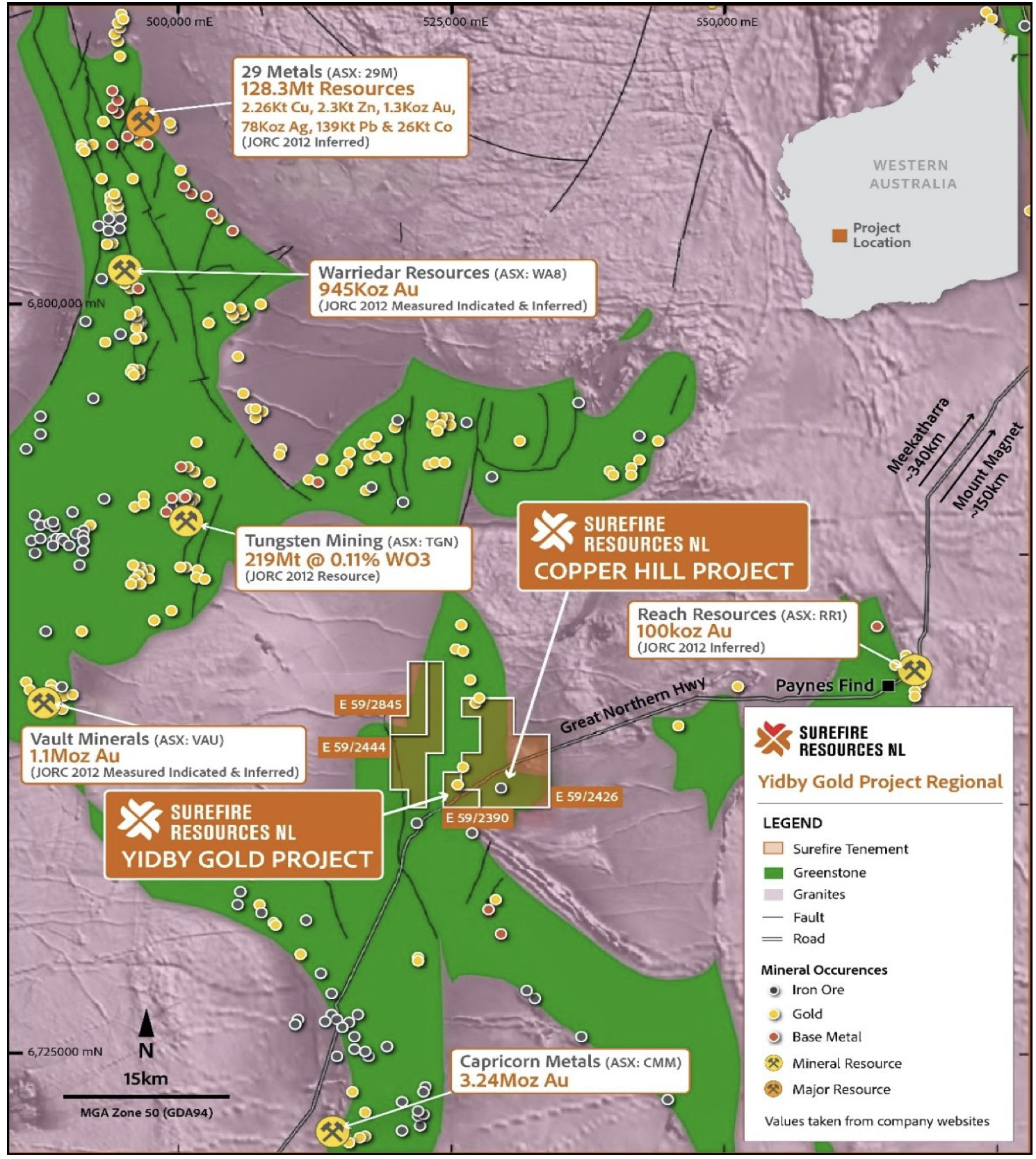
Location of Surefire Resources Copper Hill Project.
Recent drilling has confirmed significant copper mineralisation within a broad sulphidic zone, coinciding with an extensive anomalous soil geochemical target. Coupled with petrographical study findings, the company believes this represents a substantial advancement in the project, providing a strong basis for further targeted exploration for massive sulphide deposits within this newly identified VMS system.
The petrographic study focused on reverse circulation (RC) drill hole PBRC010, which returned the highest assay results from the reconnaissance drill program. Assay data indicate increasing copper values from 32 metres to the maximum drilled depth of 64 metres, with concentrations ranging from 1,695 parts per million (ppm) to 2,010 ppm. Notably, the highest copper assays were recorded at the bottom of the hole.
Geochemical analysis also identified anomalous levels of lead, zinc, antimony, and sulphur—up to 2.73%—consistent with VMS-style mineralisation.
What’s next?
Surefire has proposed a MLEM survey, a reconnaissance-style transient electromagnetic (TEM) technique designed to identify electrically conductive mineralisation (such as copper and gold) and other subsurface features.
Copper-dominated VMS deposits are typically highly conductive, regardless of whether they occur as stringer, semi-massive, or massive sulphide textures. This makes electromagnetic (EM) methods the most suitable geophysical technique for aiding discovery.
The survey will consist of approximately 125 stations along nine survey lines, employing 200-metre transmission (TX) loops and 100-metre spaced stations.
Survey Parameters:
- EM Receiver – SMARTem24, multi-channel, 24-bit receiver system
- EM Transmitter – DRTX, up to 150V input with 100 AMP TX current
- EM Sensor – X, Y, and Z component B-field Fluxgate
- Configuration – MLEM with 200-metre by 200-metre TX loops and 100-metre station spacing
- Base Frequency – ~1Hz (to be confirmed)
- Transport – All-terrain vehicle (ATV) and utility task vehicle (UTV)
See below for further details on the planned survey layout.
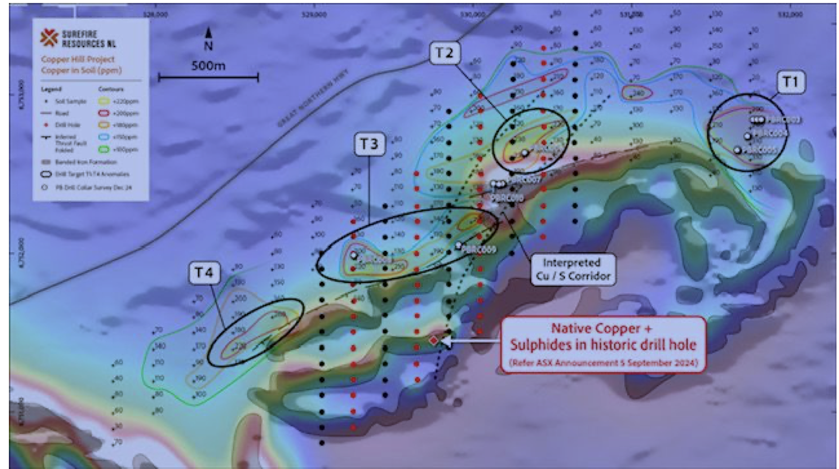
Proposed MLEM survey layout – Red stations are the Priority lines while the black stations are priority.
Note: pXRF data is used as an exploration tool and a guide only and should never be considered a proxy or substitute for laboratory analysis. The measurements recorded are for a single spot location and may not be representative of the whole rock. Only subsequent laboratory geochemical assay can be used to determine the widths and grade of mineralisation.