
Fathom Nickel Inc (CSE:FNI, OTCQB:FNICF) CEO Ian Fraser joined Proactive to discuss exciting results from a recent drone survey at the Gochager Lake nickel project in Saskatchewan.
He highlighted how various data points, such as geophysical and electromagnetic surveys, are lining up to give greater confidence in the exploration targets.
Next steps include additional on-the-ground work before winter and the potential for aggressive drilling efforts if electromagnetic surveys confirm the targets.
Proactive: News about some results from a drone survey that you ran over the Gochager Lake property. It’s exciting when you get soil results that you had before, and that sort of backed up by what you're seeing from the drone.
Ian Fraser: Exactly. The more things that you can stack up, correlating with one another, the better. It gives you greater confidence with respect to these developing targets. We know we have the necessary host rock, and it's open along strike. The soil geochemistry is demonstrating that. Now, with positive total intensity magnetic signatures, we’re seeing the same thing with these mafic-ultramafic rocks that should have slightly higher magnetic intensity.
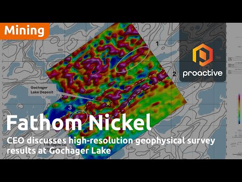
I noticed in the news release you talked about this zone within a broader regional feature with an “eye-like” signal. Can you explain what that means and what it’s showing you?
Yes. When we looked at the historic VTEM data a year and a half ago, some geophysical consultants put together a litho-structural interpretation based on the magnetic data from that 2008 survey. They defined a thrust or shear-like feature running through the northeast part of the grid flown in 2008, exiting the southeast side, and along that feature is the Gochager Lake deposit. They also interpreted several other Gochager-like features along this thrust.
Now that we’ve zoomed in over Gochager, using high-resolution magnetic data, we’re seeing a liniment, a northeast-southwest structure, with a bulge where the Gochager Lake deposit is. This suggests the thrust could be an area where the crust opened, allowing magmas to penetrate. What’s exciting is there are several other high-priority targets along this thrust, making this a great first step with more work to do.
What’s next? Does this mean drilling, or is there more desktop geology you can do?
We’ve developed a good methodology for approaching this. I hope to get out there before the snow flies. We'll put a grid on the ground and conduct follow-up geophysical surveys from the surface because electromagnetic surveys have worked well subsurface. If these coincident soil anomalies and magnetic anomalies light up with the electromagnetic survey, we’ll have a bona fide drill target and will likely pursue aggressive drilling in the winter.
Quotes have been lightly edited for clarity and style